A New Era in Land Management
In today’s evolving landscape of rural property ownership, technology continues to reshape how landowners steward and protect their investment. Among the most impactful advancements in recent years is thermal drone technology. Once limited to military and large-scale commercial use, thermal imaging drones are now accessible tools for private landowners, farmers, and hunters who are serious about responsible management and long-term success.
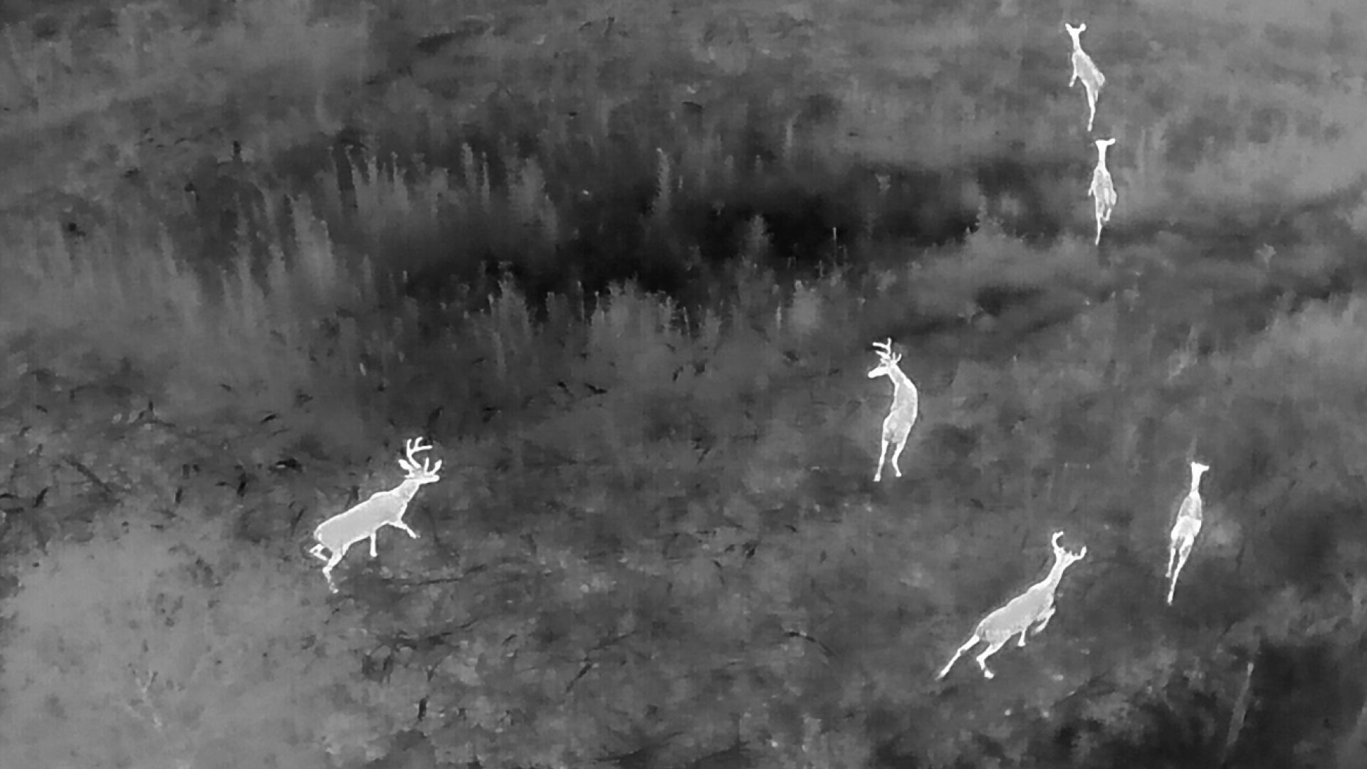
Thermal drones detect heat signatures rather than relying on visible light. Unlike traditional cameras that depend on daylight and clear conditions, thermal sensors reveal temperature differences, allowing users to identify wildlife, livestock, and other heat-emitting objects even in complete darkness or through light vegetation. This capability transforms how large, wooded, or agricultural properties are evaluated and monitored.
Seeing the Land Clearly
For owners of expansive acreage, gaining a comprehensive understanding of the property can be challenging from ground level. Dense timber, rolling topography, and thick bedding cover often limit visibility. Thermal drones provide a broader aerial perspective while simultaneously revealing the presence and movement of wildlife that might otherwise remain unseen.
Instead of relying solely on strategically placed trail cameras that capture activity in isolated areas, thermal imaging offers a sweeping view of how animals utilize the land as a whole. This allows landowners to assess population densities, observe movement patterns, and better understand how habitat features influence wildlife behavior without causing unnecessary disturbance.
Improving Habitat and Stewardship
Thermal technology enhances habitat management by identifying bedding areas, feeding zones, and travel corridors with greater accuracy. When landowners can clearly see how wildlife interacts with their property, decisions regarding timber thinning, prescribed burning, food plot placement, and water sources become more informed and strategic.
Rather than reacting to assumptions, property owners can make proactive adjustments based on observable data. This approach not only improves hunting opportunities but also strengthens long-term conservation efforts. Responsible stewardship begins with knowledge, and thermal drones provide a level of clarity that was once unavailable to private landowners.
Supporting Ethical and Effective Hunting
For hunters, preparation and understanding are essential components of ethical pursuit. Thermal imaging can assist in locating populations of feral hogs that damage crops and disrupt native habitat, making control efforts more efficient and targeted. In areas where predator populations affect fawn recruitment or livestock, thermal observation provides valuable insight before management decisions are made.
When regulations allow, thermal technology can also aid in recovery efforts by helping locate wounded game quickly and humanely. Efficient recovery reflects respect for the resource and reinforces the principles of fair chase and responsible harvest.
It is important to emphasize that all drone use must comply with local and state wildlife regulations. Agencies such as the Alabama Department of Conservation and Natural Resources and the Georgia Department of Natural Resources establish guidelines to preserve wildlife populations and protect ethical hunting standards. Technology should serve stewardship, not diminish it.
Enhancing Property Security and Oversight
Beyond wildlife management, thermal drones offer practical benefits for overall property oversight. They can assist in locating stray livestock, monitoring fence lines, identifying potential trespassing activity after dark, and even detecting abnormal heat signatures that could signal fire risk.
For properties spanning dozens or even hundreds of acres, these capabilities provide an added layer of security and efficiency. Landowners gain peace of mind knowing they can monitor their investment quickly and effectively without physically traversing every acre.
Bridging Tradition and Innovation
Rural land ownership has always been rooted in tradition, legacy, and respect for the outdoors. Thermal drones do not replace those values; they strengthen them. By blending time-honored stewardship practices with modern technology, landowners are better equipped to preserve habitat, protect wildlife, and enhance the recreational and economic value of their property.
Effective management ultimately comes down to clarity and informed decision-making. Thermal drone technology offers a clearer view of the land and the life it supports. When used responsibly and within regulatory guidelines, it becomes a powerful ally in protecting both property and heritage for generations to come.
Featured Video & Credit
To see thermal drone technology in action and better understand how heat signatures can reveal movement across terrain, check out the following video demonstration:
📺 Watch this video on YouTube by clicking the video box to visualize the capabilities of thermal drone imaging in outdoor environments.
Video credit: Savage Tactical Recon – Thermal Drone Services